Solution
What We Built
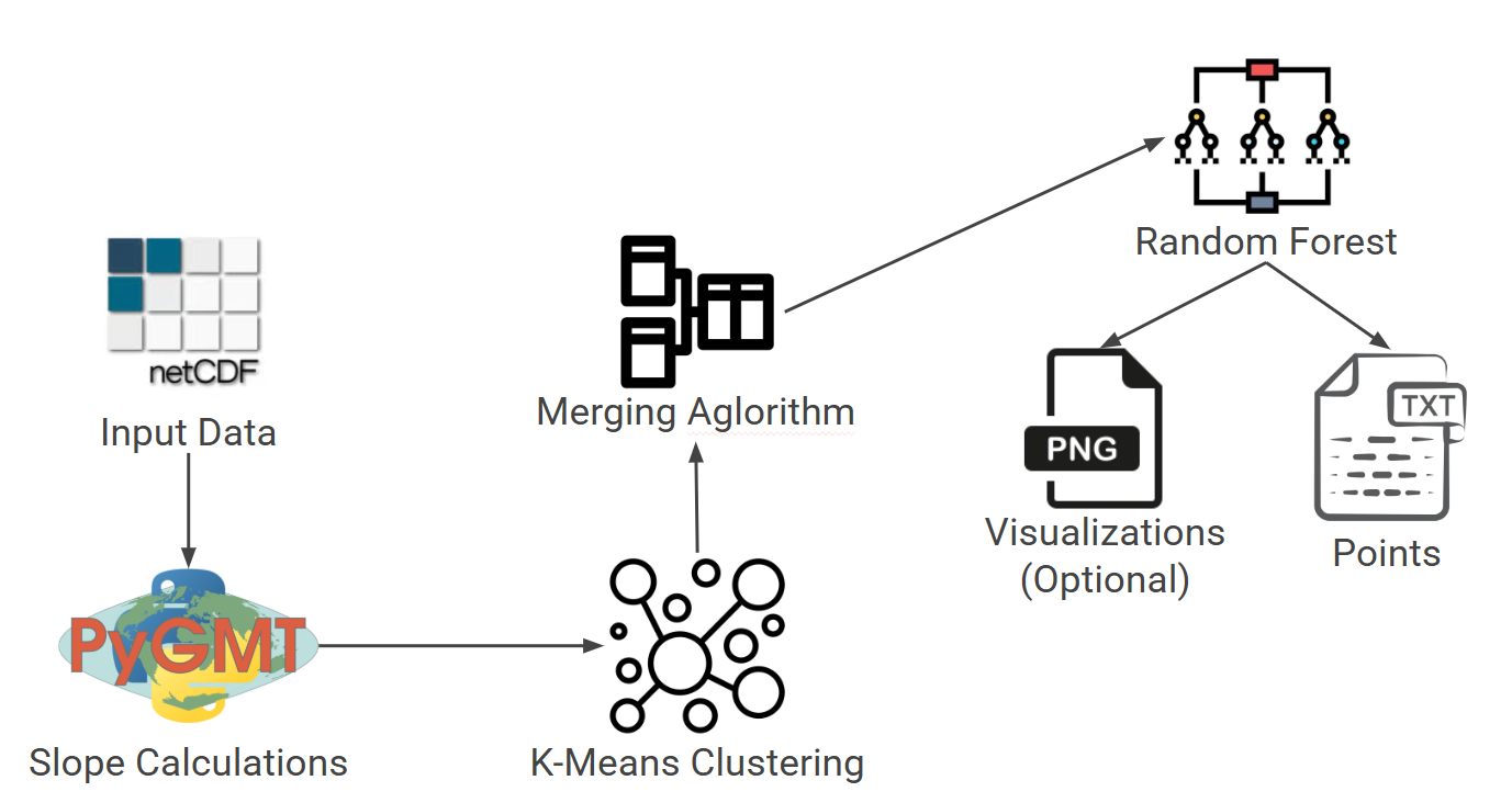
SeismoScan is designed to automate the process of identifying submarine faults in bathymetry datasets. The envisioned solution is a command line application that processes seafloor depth data, applies a hybrid machine learning pipeline, and outputs a set of fault predictions in a structured and usable format.
The system reduces the time and effort needed for manual fault mapping and produces consistent, repeatable results. It is built for researchers who work with large bathymetric grids and need a tool that can highlight likely fault structures quickly and accurately.
Key Capabilities
- Load NetCDF bathymetry datasets as input
- Preprocess and clean elevation/depth data
- Analyze slope, curvature, and spatial gradients
- Detect fault-like linear features using machine learning
- Group detections into continuous fault segments
- Export predicted fault coordinates to a text file
- Provide optional confidence scoring and debugging logs
- Support configurable runtime options
High-Level Workflow
The envisioned workflow for SeismoScan includes four major phases:
1. Data Ingestion
- Load bathymetry data from a NetCDF file (.grd)
- Convert raw data into a standardized internal format
- Extract latitude, longitude, and depth grids
2. Preprocessing
- Compute slope and other spatial derivatives
- Normalize elevation data for consistent analysis
- Segment regions of interest if needed
- Optionally downsample or smooth noisy areas
3. Machine Learning Pipeline
- Apply a clustering model to identify potential fault pixels
- Use a merging algorithm to connect adjacent detections into structures
- Apply classification logic to distinguish faults from noise
- Produce intermediate logs and confidence metrics
4. Output Generation
- Export predicted faults as latitude/longitude pairs
- Include fault IDs or grouping labels
- Store optional confidence scores in a secondary output file
- Produce debug logs when enabled in the configuration file
How This Solves the Problem
SeismoScan provides researchers with a streamlined, automated approach to interpreting seafloor data. Instead of manually scanning thousands of grid cells and tracing potential faults by hand, the system delivers a structured set of predictions that identify areas worth investigating.
By combining machine learning models with preprocessing and clustering techniques, the solution increases consistency, reduces human error, and enables much faster analysis than traditional manual workflows.
User Experience
The system is designed to be simple to run and easy to incorporate into existing research workflows. Users interact with SeismoScan through a command line interface and provide:
- A bathymetry file (.grd)
- Provided configuration files
After the process completes, the user receives a clearly formatted text file containing the predicted fault coordinates. Optional logs and confidence metrics help users understand why certain features were identified.
Success Criteria
- Accurate detection of fault-like structures
- Consistent results when reprocessing the same datasets
- Significant reduction in manual processing time
- Usable output format for geological interpretation
- Stable performance on real-world bathymetry data