

Ben Annen, Erik
Hornaday
Department of Civil
& Environmental Engineering, Northern Arizona University, Flagstaff, AZ
86001

In attempt to become a more pedestrian-friendly campus
and increase parking capacity, NAU has planned to construct several parking
structures on the perimeter of campus.
BEL Consulting has provided civil engineering services for the proposed
parking structure located at parking lot P28 on the NAU campus. A Programming Report has been produced in
order to outline the major project elements.
A Traffic Analysis Report has been developed for existing and projected
traffic conditions along S San Francisco St near the site of the proposed
parking structure as well as the existing parking lot. BEL Consulting has also determined the
location and size of the proposed parking structure. Each floor layout has been designed with a
conceptual drainage plan as well as a signage and marking plan. BEL Consulting has designed an exterior site
plan and demolition plan, which display how the proposed parking structure
ties into the existing site. The final
design includes the Programming Report, Traffic Analysis Report, and the Final
100% Plans.


The layout of each level in the parking structure was
engineered and plans were produced. A
desired capacity of approximately 500 parking spaces and a maximum height of
five levels directed the design of the layout.
Structural Engineer Bill Mancini assisted in sizing and locating
structural features. The layout of each
level was designed around these structural features. The
parking structure contains
four levels with the
EGR Design
Ayers
Saint Gross, (2008). Northern Arizona
University Draft Master Plan Update.
HiCAP. Computer software. Vers. 2.0. Tucson, AZ: Catalina
Engineering Inc., 2003.
Hook,
David, PE. Project Manager. NAU
CAS.
Mancini,
Bill, PE, SE. Mancini Structural Engineering. Conference Call. 12 Feb.
2009.
Maricopa Association of Governments. Uniform Standard Specifications for Public Works
Construction. By Standard
Specifications & Details Committee. 2009th ed. Phoenix, 1998.
NAU Parking Services, (2009). Northern Arizona
University-MCT Bus Routes. Accessed on January 21, 2009, from http://home.nau.edu/parking/busroutes.asp.
Transportation Research Board, (2000). Highway Capacity Manual. Washington,
D.C.: National Research Council.
United States Access Board, (2002). American Disabilities Act Accessibility Guidelines
for Buildings and Facilities. Accessed on February 1, 2009 from http://www.access-board.gov/adaag/html/adaag.htm.
Weant, Robert A., and Herbert S. Levinson, (1990). Parking.
Westport, CN. Eno Foundation for Transportation.


Faculty: Dr. Joshua
Hewes, PE, PhD (Assistant Professor);
Dr.
Charles Shinham, PE, PhD (Assistant Professor)
Advisors: Bill Mancini, PE, SE (Structural Engineer); David Hook,
PE (Project Manager, NAU
Capital Assets and Services); Shannon Clark (Facilities Engineer, Coconino National Forest)
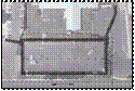

An exterior site plan was produced to complement the
implementation of the parking structure.
The 320 ft x 128 ft footprint of the structure was positioned in
relation to the existing parking facility.
From this, sidewalks and crosswalks were placed between pedestrian
access points of the structure and areas of interest on campus. Landscaping areas were designated on the east
and west sides of the structure.
Locations of electrical, storm sewer, and reclaimed water lines were
shown on this plan. Two concrete pads
for bicycle racks were located adjacent to the structure. Concrete aprons were added to the vehicular
access points to allow for a smooth transition between the structure and the
existing surface conditions. These
features are shown in Exhibit 2.
A traffic
analysis was performed on and near the project site in attempt to understand
the traffic patterns of the existing and projected conditions. Three unsignalized intersections located on
S San Francisco St were analyzed using Highway Capacity Manual (HCM) methods
along with turning movement counts provided by the client’s representative,
David Hook. The three intersections
included S San Francisco St at E Franklin Ave, Mountain View Rd, and W
University Dr. The delay and level of
service (LOS) for the existing and projected conditions of each intersection
were determined, as shown in Exhibit 1.
The ingress
and egress movements of the project site occur at the intersection of S San
Francisco St and Mountain View Rd. The
implementation of a parking structure causes an increase in ingress and egress
movements of the project site. This
increase results in a decline of the LOS from D to F. The increase also causes the LOS of the
approach to decrease from B to E.
By implementing a parking structure at this location,
the parking capacity increases by 320 parking spaces, or 252%. This provides increased parking for
employees, residents, and commuters.
Most of the nearby parking lots only provide for residents. Therefore, the proposed site improvements
provide a greater variety of users accessibility to this area of campus.
As the proposed footprint of the parking structure was
located on an existing parking lot, several features were to be
demolished. The demolition plan
included removing and disposing of the following; asphalt concrete pavement,
concrete sidewalk, concrete curb and gutter, parking striping, landscaping,
and lighting fixtures. Several existing
utilities had to be relocated due to the footprint location. These utilities included water lines, gas,
power, and lighting. Along S San
Francisco St, several branches of the ponderosa pines must be trimmed to allow
for the construction of the parking structure.
A conceptual drainage plan was produced for each
level. The drainage method used was
that of a “W” shaped floor. The “W”
shape causes the slope of the floor to reverse every three parking
spaces. High and low points make up
the “W” shape with the net slope directed toward the center of the
structure. Area drains were located
along the center of the structure at the low points of the “W” in order to
intercept the runoff. The area drains
were connected to a piping system, which carries the runoff to the main storm
sewer line located below the structure.
Drainage features are shown in Exhibit 4.
A signage and marking plan was developed for each level
of the parking structure. Sign types
included both federal and general. The
federal signs conformed to the MUTCD standards while the general signs were
developed to provide guidance and clarity.
Sign types, locations, and orientations are shown on the signage and
marking plans using symbols that correspond to sign types on a Sign Schedule. For example, sign “S2” on the plan sheet
represents an “Entrance” sign, as shown on the Sign Schedule. A portion of the Sign Schedule and a screen
shot of one plan sheet are shown in Exhibit 5.
The complete Sign Schedule and sign details are shown on a detail plan
sheet. Markings are also shown on the
signage and marking plan. Marking
material was determined to be alkyd paint.
Such markings are directional arrows, clear space areas, and handicap
symbols. Details of these markings are
shown on a detail plan sheet. The
combination of signage and markings allow for users of the parking structure
to have clear direction which promotes safety.
Abstract

Exhibit 1. LOS of Each Intersection
E Franklin Ave
and
S San Francisco St
Mountain View Dr
and
S San Francisco St
W University Dr
and
S San Francisco St
Existing
Delay (s), LOS
30.3, D
28.2, D
56.3, F
Projected
Delay (s), LOS
444.8, F
400.4, F
543.7, F

NAU Parking Structure Site Planning and Site Design

Traffic Analysis

Exterior Site Plan

Level Layout

Drainage

Signage and
Markings

References

Acknowledgments

Exhibit
4. Drainage
Exhibit
2. Exterior Site Plan


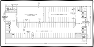
layout of Level 1 shown in Exhibit 3. Laying out each level included sizing,
locating, and orienting the parking spaces.
The first level contains all of the handicap parking. Levels 2, 3, and 4 include regular parking
spaces (8.5 ft x 19.5 ft) as well as compact parking spaces (7.5 ft x 16
ft). Parking spaces were also placed on
the ramp, which was located on the west side of the structure. The layout also included the location and
size of vehicular and pedestrian access points. The parking structure included one vehicular
access point at both the north and south ends.
Pedestrian access points were located near the stairwells as well as at
the northwest corner of the structure.
Two stairwells were positioned in opposite corners of the structure
along with an elevator in the southwest corner. Storage space was designated under
the second level
ramp
and the stairwells.
Due to an existing bus stop on S San Francisco St, the first level of
the structure includes a clear space protected by bollards as a waiting area
for bus users. Several other clear
spaces are included on each level that allow for greater vehicular
maneuverability. The final layout of
each level contributed to a four level parking structure with a capacity of
475 parking spaces.
Exhibit
5. Signage and Markings
Exhibit
3. Level 1 Layout


Project Summary
The proposed four level parking structure will increase
the parking capacity of the existing site by 320 parking spaces, or 252%. The facility will accommodate residents,
employees and commuters. Crosswalks,
sidewalks, and bicycle rack pads are all proposed to make NAU a more
pedestrian-friendly campus, a large goal of the NAU master plan.

Demolition