

Miller Creek Flood Plain Revision and
Crossing Feasibility Study
Department
of Engineering and Natural Sciences, Northern Arizona University, Flagstaff,
AZ
Mike
Carroll, Gordon Hastings, Brian Kunk
Hydrology

Crossing Feasibility

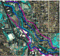
Federal Insurance
Rate Map

Special Thanks go to:
The
first step when designing any structure in an active channel is
to replicate the hydraulic model used to construct the current Federal
Emergency Management Agency (FEMA) Flood Insurance Rate Map (FIRM).
The FIRM for this study area was completed using the US Army
Corps of Engineers Hydraulic Engineering Center’s HEC-2 hydraulic
modeling program. Unfortunately, FEMA could not provide the HEC-2
data for the study area within the time limits of this project.
Therefore the model could not be replicated. This prevented the
calibration of the hydraulic model the team created using the
Hydraulic Engineering Center’s River Analysis System
(HEC-RAS) program with the model (HEC-2) used to create the
current FIRM.`
The
inability to calibrate the new model requires more documentation
regarding the discrepancies, if any, between the two
mapped flood elevations. The missing HEC-2 model does not
negatively affect the solution that BackWater has proposed using
the HEC-RAS model of Miller Creek.

Conclusion

Abstract
The
purpose of the project is to revise the current hydraulic model
of a portion of Miller Creek, north of Prescott, and to conduct
an elevated crossing conceptual design to replace a current
low water crossing. The intent is to reduce the instance of
conflicts between stormwater runoff and human activity.
The
current floodplain model is out of date with respect to the hydraulic
and hydrologic methods and technology used by floodplain managers
today. In addition, the current low water crossing is dangerous to
motorists and pedestrians during moderate to extreme storm
events. The goal of Backwater Engineering is to produce an accurate hydraulic model of the 10, 25 and 100 year events being contained within Miller Creek and to produce a conceptual design of an elevated crossing within the vicinity of Lincoln Avenue. The City of Prescott will further utilize the outcomes
of the project to improve their city-wide floodplain database and to
eventually completely design and build an elevated crossing.
The
analysis of Miller Creek began by determining the design flowrates
that were to be used in the hydraulic model. The City of
Prescott provided BackWater with a set of design flowrates for
the 10, 25 and 100 year events along Miller Creek. In addition
to the provided design flows, Backwater performed a simplified
hydrologic study of the two watersheds of interest and
produced an accessory set of design flowrates for the 10, 25
and 100 year storms.
There
are two main watersheds, Miller and Butte that contribute to the
conveyance of Miller Creek within the project area. The two
watersheds collectively maintain ten square miles of land area consisting
of similar land uses and soil strata.
The two sets of data
were
comparable within 17%
difference for the Miller
watershed and 55%
difference for the Butte
watershed. The percent
differences were
acceptable but it was
decided,
in coordination with the client, that the provided design
flowrates should be used to produce the hydraulic model.


Hydraulics
BackWater
Engineering found the major safety concerns for the current
low water crossing to be:
•Extended
period of road closure
•Unsafe driving
conditions due to ice and water on the roadway.
•The presence
of a steep approach leading to Miller Valley Rd.
•The
possibility of flash flooding and stranded motorists.
•Lack of
turnaround area when crossing is closed.
The environmental
concerns are:
•Excessive soil
erosion.
•Contaminants
due to vehicles traveling through.
BackWater
Engineering assessed different locations to find an alternate
location with moderate constructability, low cost, and low
traffic impact. The current low water
crossing location was considered for elevated crossing
construction, but dismissed due to cost and traffic impacts. BackWater Engineering recommends
building an elevated crossing at Madison Ave. because this
location provides minimal cost, minimal traffic impacts and average
constructability. The City of Prescott currently
owns the right of way to construct a crossing at this location
therefore is no required taking of private land.
BackWater
Engineering analyzed multiple box culverts using HEC-RAS. A 24’ wide by 7’ tall culvert will convey
the 100 year storm event while having weir flow of 1.2’above the
crossing, and would cost approximately $ 108,000.00. Two 20’ wide 7’ tall
box culverts would fully convey the 100year storm event with
no overtopping and have an approximate cost of $ 137,000.00.
The
discrepancies between the flood delineation on the current Flood
Insurance Rate Map (FIRM) and the HEC-RAS modeled flood
delineation cannot be reconciled without the missing HEC-2
data. This does not invalidate the constructed model, but
adds additional documentation requirements to the project.
The
length of crossing and intersecting flows from Butte Creek and
Miller Creek make constructing an elevated crossing at Lincoln
Ave prohibitively costly. A crossing at Madison Ave would
be one third the length and not have to contend with converging
stream flows. It is recommended that the City of Prescott
construct an elevated crossing at Madison Avenue.

References
Mr. Greg Toth, City of
Prescott Stormwater Manager
Ms. Ann-Marie Benz, Prescott
Creeks
Dr. Bob Shinham, Technical
Advisor
Dr. Wilbert Odem, Project
Review
Dr. Joshua Hewes, Overall
Project Guidance
City
of Prescott Stormwater Management Plan
Federal
Emergency Management Agency (FEMA) Letter of Map Revision (LOMR)
Guidelines
American Association of State Highway Transportation
Officials (AASHTO) – Geometric design of Highways and Streets (Green Book)
Arizona
Department of Water Resources (ADWR) Floodplain Hydraulic Modeling
Army
Corps of Engineers Hydraulic Engineering Center River-Analysis System
(HEC-RAS) Documentation
Army Corps of Engineers Hydraulic Engineering
Center-Hydrologic Modeling System (HEC HMS) Documentation


A
detailed roughness investigation is imperative to the accuracy
of hydraulic models which represents the natural channel
setting. Due to the variable
vegetation and landscape
along Miller
Creek, BackWater has
performed an
extensive field study of the
channel
conditions currently within
the study limits.
The conditions varied from
very rough with
dense vegetation and rock
outcrop to
partially smooth with no
vegetation and a
sand bottom.
The
10, 25, 100 year precipitation events were hydraulically modeled
to determine respective flood elevations and stream velocities
for the portion of Miller
Creek within the project
area. The
hydraulic model of Miller Creek
consists of fifteen cross
sections,
each of which represents the
geometric and roughness
conditions
of a portion of Miller Creek. The
hydraulic depth is found at
each
successive
cross section and interpolated in between to completely define
the 10, 25 and 100 year water surface elevations.


Miller Creek watershed

Butte Creek watershed